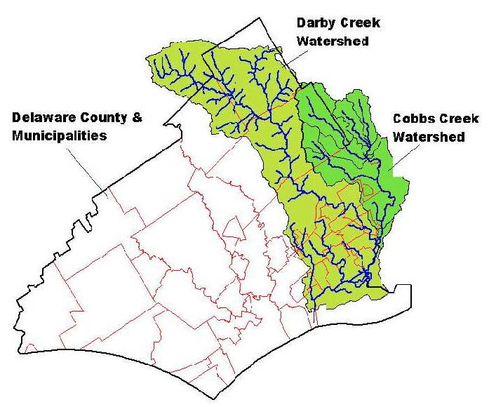
Map of Darby Creek & Cobbs Creek Watershed
Flow Facts
Area: 78 square Miles
Population within Watershed: Approximately 500,000 people
| DEP Stream Designations/ Uses: | |
|---|---|
| Stream: Segment: Designation, Use: | Darby Creek Main Stem, Source to PA 3 Bridge Cold Water Fishery, Migratory Fishes |
| Stream: Segment: Designation, Use: | Unnamed Tributaries to Darby Creek Basins, Source to PA 3 Bridge Cold Water Fishery, Migratory Fishes |
| Stream: Segment: Designation, Use: | Little Darby Creek Basin Cold Water Fishery, Migratory Fishes |
| Stream: Segment: Designation, Use: | Camp Run Basin Cold Water Fishery, Migratory Fishes |
| Stream: Segment: Designation, Use: | Miles Run Basin Cold Water Fishery, Migratory Fishes |
| Stream: Segment: Designation, Use: | Foxes Run Basin Cold Water Fishery, Migratory Fishes |
| Stream: Segment: Designation, Use: | Darby Creek Non-Tidal Portion of Main Stem, PA 3 Bridgeto Mouth Trout Stocking Fishery, Migratory Fishes |
| Stream: Segment: Designation, Use: | Unnamed Tributaries to Darby Creek Non-Tidal Portions of Basins, PA 3 Bridgeto Mouth Warm Water Fishery, Migratory Fishes |
| Stream: Segment: Designation, Use: | Whetstone Run Non-Tidal Portions of Basins Warm Water Fishery, Migratory Fishes |
| Stream: Segment: Designation, Use: | Cobbs Creek Non-Tidal Portions of Basins Warm Water Fishery, Migratory Fishes |
| Stream: Segment: Designation, Use: | Hermesprota Creek Non-Tidal Portions of Basins Warm Water Fishery, Migratory Fishes |
| Stream: Segment: Designation, Use: | Muckinipattis Creek Non-Tidal Portions of Basins Warm Water Fishery, Migratory Fishes |
| Stream: Segment: Designation, Use: | Stony Creek Non-Tidal Portions of Basins Warm Water Fishery, Migratory Fishes |
| Counties: Chester, Delaware, Montgomery, Philadelphia | |
Municipalities
Chester County Municipalities:
Tredyffrin Twp., Easttown Twp.
Delaware County Municipalities:
Radnor Twp., Newtown Twp., Marple Twp, Haverford Twp., Upper Darby Twp., Springfield Twp. Millbourne Borough, Lansdowne Borough, East Lansdowne Borough, Clifton Heights Borough, Morton Borough, Aldan Borough, Darby Borough, Yeadon Borough, Collingdale Borough, Darby Twp., Rutledge Borough, Ridley Twp., Ridley Park Borough, Prospect Park Borough, Glenolden Borough, Sharon Hill Borough, Colwyn Borough, Folcroft Borough, Norwood Borough, Tinicum Twp.
Montgomery County Municipalities:
Lower Merion Twp., Narberth Borough, Philadelphia County: City of Philadelphia
Watershed Groups and Partnerships
Darby Creek Valley Association, Darby-Cobbs Partnership River Conservation Plan: The Darby Watershed Conservation Plan Cobbs Management Plan: Draft Document Act 167 Plan- This comprehensive stormwater management plan has been completed and should have been adopted by all municipalities in the watershed. Contact your local official for a copy of the ordinance.
History/Description
The Darby watershed is a developed urban area. Historically the development dates back to the first days of William Penn and Swedish settlers that called the area home in the late 1600’s. Over the last several centuries the area has become mostly urban with some suburban locales along the northern and eastern fringes. Flooding and stormwater have plagued the watershed due to over-development and failed or nonexistent stormwater controls. The watershed is relatively small, but contains many local governments including the City of Philadelphia.
The Darby Creek flows into the Delaware River just below Philadelphia International Airport. Priority sites: John Heinz National Wildlife Refuge Projects: Bartram Park Streambank Restoration Link to Stream flow- USGS does not operate a gauging station on this watershed.
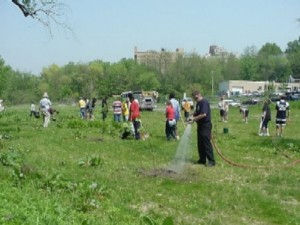
Riparian buffer restoration at Bartram Park in Darby
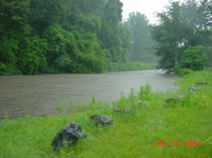
July 17, 2004 flooding along Bartram Park in Darby
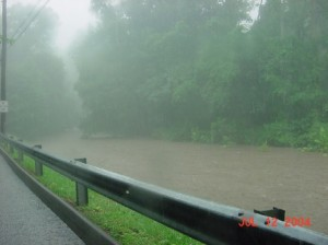
July 17, 2004 Flooding along Scottdale Rd. in Lansdowne
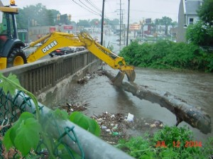
July 17, 2004 Debris collection at MacDade Blvd. Bridge in Darby during flood event