Rivers Initiatives
Streams and their watersheds serve as a basis for County plans that address natural, cultural, recreational, and economic assets.
Commercial, industrial, natural, and recreational resources are all elements considered in a river or watershed plan. County staff actively participate in planning activities that fall under Pennsylvania’s two river-related programs. Both programs recognize the importance of preserving and enhancing the unique resources that lie within the multi-faceted areas that make up the area of land and water interface along rivers.
Coastal Zone Management
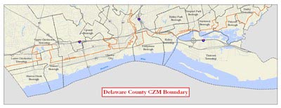
The Delaware County Coastal Zone extends along the Delaware River waterfront for 12 miles from Tinicum Township to Marcus Hook Borough. Generally following the Route 291/13 corridor, this area has continued to be the location of many of the County’s industries and port facilities. However, the 13 municipalities that lie within the area also contain unique aesthetic, environmental, cultural, recreational, and historic resources. The area has been identified as having considerable redevelopment potential, as evidenced by Talen Energy Stadium, Harrah’s Philadelphia Casino and Racetrack, and offices at the Wharf at Rivertown in Chester. It will also contain a segment of the East Coast Greenway bikeway.
Planning staff sit on the regional Delaware Estuary Coastal Zone Advisory Committee. It coordinates with the Pennsylvania Department of Environmental Protection (DEP) Water Planning Office, the Delaware Valley Regional Planning Commission, and other waterfront counties in the region on matters relating to the Pennsylvania’s Coastal Zone.
DEP’s Coastal Resources Management Program administers a grant program funded by the federal National Oceanic and Atmospheric Administration for projects in the Coastal Zone. Planning Department staff are familiar with Coastal Zone programs and policies and can assist with preparation of a Coastal Zone grant application.
Coastal Zone Projects and Activities
The Planning Department, through the Delaware County Coastal Zone Task Force, works closely with the municipalities and stakeholders to reinvigorate the Coastal Zone and draw attention to its resources.
The Planning Department regularly receives grant funding from DEP for the preparation of studies and the initiation of projects affecting Delaware County’s Coastal Zone resources. Planning projects have included inventories and studies relating to land use planning for the area, beautification of the Route 291/13 Industrial Heritage Parkway area, implementation of the East Coast Greenway bikeway, and design and installation of interpretive signage throughout the Delaware River corridor.
Rivers Conservation Plans
A Rivers Conservation Plan (RCP) serves as a vision that can be used by study area municipalities to guide conservation and development efforts into the future. The primary purpose of an RCP is to address concerns and threats to the river resources. This is accomplished through preparation of a plan that identifies river watershed resources and makes recommendations to guide watershed conservation, restoration, and enhancement efforts. The recommendations presented in the plan provide municipalities and conservation organizations with actions that can be taken to address primary concerns and to preserve the many resources of the study area documented in the plan.
RCPs approved by the Pennsylvania Department of Conservation and Natural Resources (DCNR) are placed on the state Rivers Registry. This enables projects identified in the plan to be eligible for DCNR funding for implementation.
RCPs for Darby, Chester, Ridley, Crum, and Brandywine Creek plans can be found on DCNR’s website.
The Delaware River Watershed Conservation Plan for the Delaware River Corridor and the Naamans, Marcus Hook, and Stoney Creek Watersheds, prepared by the Delaware County Planning Department is available.

